P&K AST (TA Luft 2021 / AUSTAL)
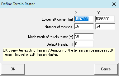
Define Terrain Raster

Form for the generation of an area height raster or information inquiry of a regular raster.
The mesh size of the area heights raster does not have to match with the mesh size of the computation grid / computing area, however the computing area must lie completely within the area heights raster. The raster may not contain invalid values (NODATA_value) or gaps and must be regular for the computation.
Lower left corner [m]
X and Y-coordinate of the lower left corner of the area. (X to the right (the east) ascending, Y upward (the north) ascending)
Number of meshes
Number of raster meshes in x and y-direction.
Mesh width of terrain raster [m]
Distance between the horizontal and vertical nodes.
Default Height [m]
The raster will be pre-set with this height.
Also see:

